
The Wrong Side of my Car
The blog that wants to go obsolete
Let’s create urban villages, North Shore edition
So, time for the North shore edition. I’ve written about a few opportunities before, and unfortunately here as well, during the life time of this blog, none of those have materialized yet. Takapuna came closest, with some urban redevelopment, but Takapuna town centre has still almost no population.

Let’s create urban villages, city centre edition
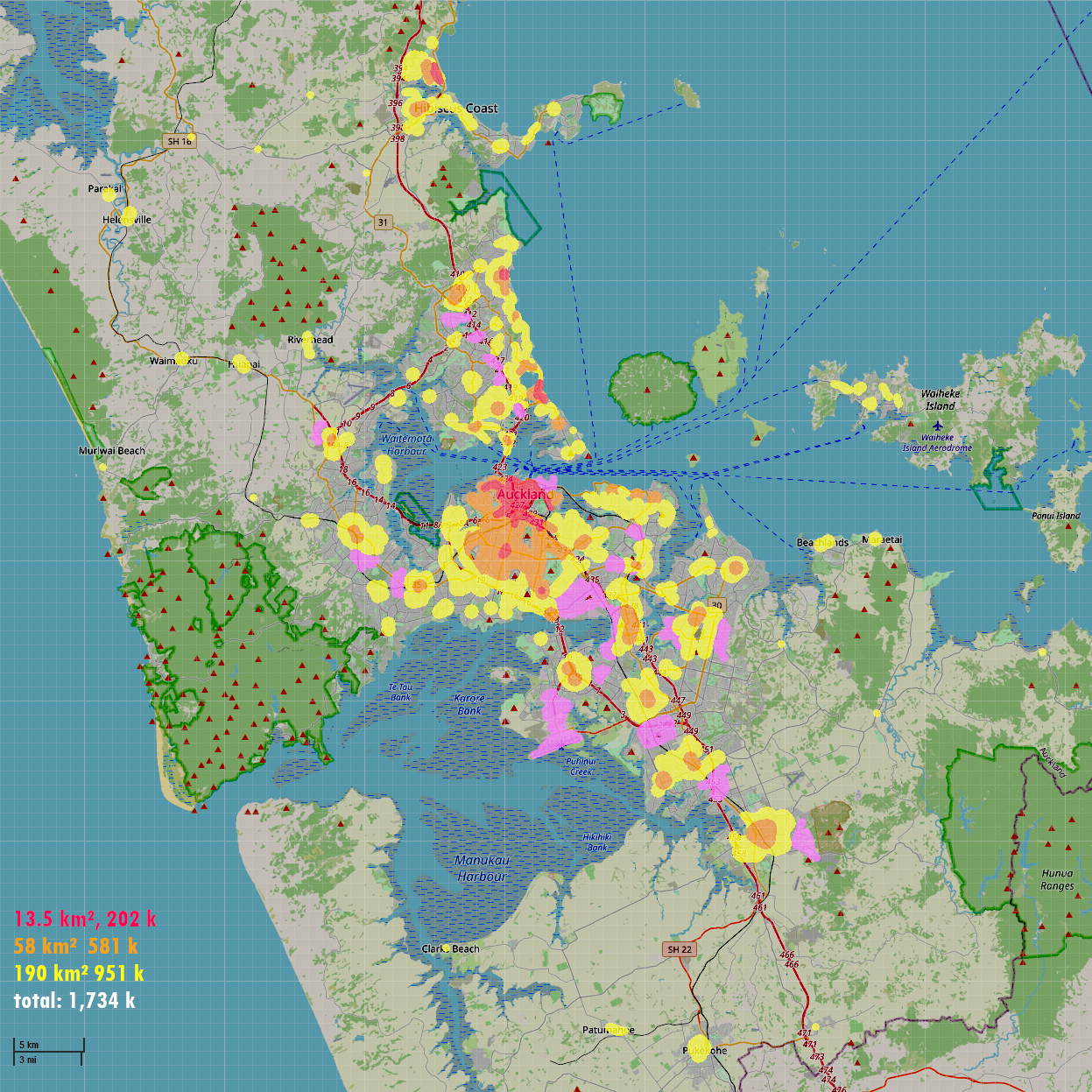
I have written before about the weird, lumpy population density of Auckland City. This is still the case, here is a similar map, from Census 2023 data. (I think dot maps are underrated for this sort of thing, there is no other way to bring out sheer differences in density like this)

Today I’m going to be looking at two of the areas where lots of people live on Hobson Street. That is the area I am more familiar with, and I’ve been there recently.

These areas have something in common: both of them are centred around a laneway. Or better: what could be a laneway, because both of them are currently languishing as sad little parking lanes. But there are also a few differences.
Is ornamentation really a crime?
1890 — Grey Lynn, Auckland.
Time to build, build, build. There’s a brand new subdivision and there’s money to be made. The streets are laid out, in a neat grid. Except that awkward hole where the swamp is. New houses, mass produced. All of them more or less the same, with their bay windows and porches. Get a load of mass produced widgets to decorate and customise their looks a bit. Tacky, perhaps, but it gets the job done. Nobody wants to live in a landscape that looks like a bunch of cardboard boxes with holes cut out, right?

What’s the deal with those backyards?
Here is something awkward for urbanists over here: if you want to raise a kid in Auckland, you need a backyard.
No ifs and buts. Backyard.

And that is very unfortunate. We keep going on and on about how we need to live smaller. Build apartments. The solution to housing crises always seems to converge to 6-storey apartment blocks*1, and Auckland is no exception.
But then you have to find people who are willing to live without a backyard.
The scale of Auckland
I sometimes tell people the scale of Auckland is mind-boggling. An endless sea of houses. Where does that impression come from?
It is of course because what I am used to in Europe. European cities have a different history, and therefore developed with a different settlement pattern. If we would have a city with that sort of pattern over here, what would it look like? How big is it?
We could come up with some imaginary settlement pattern, with about 1.5 to 1.7 million imaginary people.
Is cycling still for the rich?
Here are 2 somewhat related statements that sow division among urbanists:
- The car is the vehicle of the poor
- Cycling is for rich people
If you see these coming up you can expect mockery. However, we have census data and the so-called deprivation index, so we can actually check this. Last time we saw little evidence that either of them is wrong.
Did anything change with the 2018 census?
Imagining something else for Birkenhead
After the Harbour Bridge opened in 1959 Onewa Road became the main arterial to the city. To cope with the traffic from Beach Haven and Birkdale (presumably), part of Mokoia Road was bypassed. This presents us now with an opportunity.

Backyards
‘Backyard’ is one of those words that make a lot of urbanists full libtard. It is a taboo word and anyone who uses it is automatically an idiot and not worth listening to. *1
A backyard often comes up in discussions about high density living, and why it is necessary or not. Many people find it hard to imagine how anyone could ever tolerate life in a city without one. That is especially true for families — don’t miss that opportunity to howl the phrase “Won’t somebody please think of the children?”.
But is is said that having backyards is unsustainable, it takes too much space, so we should learn to live without one.
Census 2018 mode shares
With the travel data out for the census, we can now make our cycling modeshare GIF. Purely for posterity — the COVID-19 crisis has made all of this pretty much obsolete.


The case of the missing cross-town bus
Last year the New Network for the North Shore went live. Curiously, something is missing. These are the frequent bus routes on the lower North Shore, overlaid on the Unitary Plan map.

Is cycling for the rich?
An argument often made against bicycling is that is only for the rich, and investment in bicycling infrastructure is thus a regressive measure. A casual glance at success stories seems to confirm this. Grey Lynn. Point Chevalier. Belmont. If you want to live there you and your significant other had better both get a 6 figure salary.
Is that impression correct? One way to get an idea is to look at census data. One of the questions asked is how you get to work. This is not a perfect measure (more local errands like shopping or going out are often more feasible on a bike than commuting), but it should give us an idea of where cycling is popular.
Up or out?
One of the classic dilemmas in city planning:

Residential areas in Auckland, New Zealand versus Leuven, Belgium
New Zealanders and Belgians have quiet different ideas about what a run-of-the-mill residential area should look like. Of course the Belgian way is way better than the New Zealand way. And not just because I happen to be from Belgium.
Cottage for sale
This is the coolest auction of the year.

During my walk around Hobson Street I encountered those two little cottages between all those towers, as silent witnesses of a time when St. Matthew’s church was still dominating the skyline of Auckland. One of them is going under the hammer. They’re unique in Auckland, and not just because the somewhat surreal setting.
Let’s explore aerial photography: Auckland
Last time we looked around in Belgium, this time we will have Google Earth hoover over Auckland.
What’s so different between cities in Europe and Auckland? Auckland lies within what used to be the British Empire. Long story short, the British liked their cities Extra Large.

Let’s explore aerial photography: Belgium
Lots of people think I’m weird. I’m interested in weird things. I can spend way too much time on silly things. Like writing a blog nobody reads. “Normal” is overrated. It is often just a fancy synonym for “boring” anyway.
One of the particular things which can mesmerise me for hours are maps. New maps. Old maps. Old aerial photographs. Relief maps. Following how the streets and railways find the best way through areas with a lot of relief. And so on.
Today we have aerial photos, more specifically stills from Google Earth. Let’s have a look at what cities look like from above.

So, to “Auckland 2040” and other NIMBYs…
I see it’s fearmongering time again…
Secret housing plans for Auckland
Tens of thousands of homes in Auckland’s leafy residential suburbs are being rezoned for multiple townhouses and apartments and Auckland Council says homeowners will not be notified about the changes.
Anyone following this saga over here can probably guess who is behind that article…
Auckland 2040 and Herne Bay Residents Association co-chair Christine Cavanagh said there were serious issues of natural justice for residents of the single-house zone.
Oh, boo-hoo.
And by the way, check out the cover image of one of those other articles about this issue:

Who gives a damn at the Hobson ridge?
So. I showed you around on Hobson and Nelson Street a while ago. Suppose you’re thinking of buying an apartment in that corner of the CBD. Maybe on SugarTree, which stares you in the face every time you drive through the CBD? Or the Fiore, which is currently overgrowing that old building on the corner across the police station?

Then I’ve got good news and bad news for you. Which one do you want to hear first? The good news?
Here’s the good news: nobody gives a damn.
The bad news? Nobody gives a damn.
Let me explain the good news first.