
The Wrong Side of my Car
The blog that wants to go obsolete
The scale of Auckland
I sometimes tell people the scale of Auckland is mind-boggling. An endless sea of houses. Where does that impression come from?
It is of course because what I am used to in Europe. European cities have a different history, and therefore developed with a different settlement pattern. If we would have a city with that sort of pattern over here, what would it look like? How big is it?
We could come up with some imaginary settlement pattern, with about 1.5 to 1.7 million imaginary people.
The Ink Blob versus the Fractal

Despite a relatively modest population of about 1.5 million people, you can drive 45 km in a more or less straight line within the agglomeration. Partially this is due to the geographical constraint of being between two harbours. But it is also just the sheer amount of area that it covers.
Auckland has a dense city centre (both in terms of jobs and population, but that density falls off very sharply to a quite low and also remarkably uniform density — outside the city centre and Newmarket you get your 4000 to 6000 people per km², everywhere. Whether you’re 3 km or 15 km away from the town hall.
This effect is especially strong on the North Shore, where you can walk from Devonport to Long Bay — 20 km — with almost no variation in urban form. Auckland is basically spreading out like an ink blob into empty land, growing ever larger on the edge.
This profile is different in Europe. The centre is still the most dense but it falls off more gradually. Brussels has a few municipalities *1 with an average density of well over 10,000/km². But overall the area covered appears to be smaller. If you start on the Grand Place in Brussels, 20 km gets you out of the city, and almost to the next (Leuven is 26 km away, and Mechelen 23).
But that is not the entire story. Around the city you’ll find many smaller cities, towns, villages and peri-urban areas that effectively function as part of the city. This has nothing to do with planning but with how this area developed during centuries, from back in the day when villages were still a thing. All of these are growing larger, but it is unlikely they’ll ever completely coalesce. The settlement pattern will be all grainy and splotchy instead of one big blob *2.
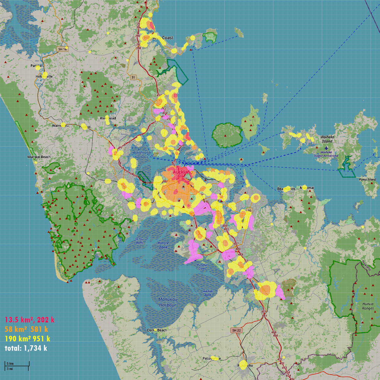
So what is this map?
I was wondering which kind of settlement pattern would fit on Auckland’s geography. So I just painted until the total area kind of checked out. (And yes I’ll admit I painted quite randomly, although I tried to figure out where existing villages and town centres are. If I forgot about yours, my apologies)
I also tried to paint industrial areas in purple, kind of corresponding to where they are in real Auckland. No, I’m not actually a planner. And where are the commercial areas? Everywhere. Many shops are just on the ground floors of the apartments and townhouses *3.
Red: 15,000/km²
The imaginary city centre and inner suburbs are densely populated. Along with smaller centres of the larger imaginary regional towns. This area is a few kilometres across. In Europe this is typically the old medieval city centre and surrounding neighbourhoods *4. If you ever visited any European city as a tourist this is almost certainly the part of the city you saw.
What does this look like?
It is comparable to our current city centre, but that is a bad representation. A couple of blocks have a density of way over 100,000, but thanks to the magic of single land use they’re surrounded by barely populated commercial blocks.
Usually you’d have a much more even settlement pattern. 15,000 is dense, but not stupidly so. It would be narrow townhouses and low-rise apartments. You’d have your larger apartment blocks too, but also open spaces like parks.
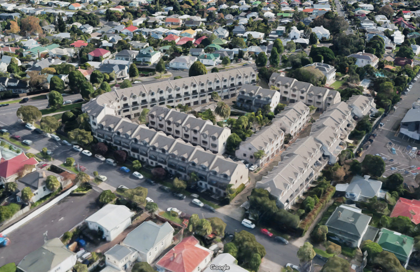
There aren’t a lot of examples in Auckland of this density. A development like Vinegar Lane, Grey Lynn will probably achieve this density, but it wasn’t yet populated during the census. There is a development in St Lukes *5 which according to the census has a density between 20,000 and 30,000. As you can see, if you dislike high-rises you’re still going to be OK.

As is fitting for Auckland, it is surrounded by completely unpopulated ‘commercial’ areas.
Orange: 10,000/km²
Surrounding it would be a substantial area with a population density somewhere in the middle. In Europe you often see a recognisable pattern of, well, Euro-blocs. *6 This tapers off to lower density on the fringe.
This density is low enough to have meaningful backyards, for those who are keen, if you get your basic layout right.
It is still surprisingly rare to see even this density in Auckland. An example is Summerfield Villas in Grey Lynn. *7 I expect Hobsonville Point to eventually have this sort of density.
Yellow: 5,000/km²
European cities have suburbs too. Plenty of examples over here of course.
Here we can have our free standing with spacious backyards. Density is low enough so you can have 300 to 500 m² of land under your house. That should be enough for your lawn and your veggie garden. (this size of sections often still feels cramped in Auckland but that is a separate rant.)

The rest: Exurban to rural
Then, the fringes. Within Europe this greatly varies by country. Some countries have neatly delineated towns and rural areas. The Dutch are good at this. Right next doors, Belgium is full of exurban sprawl. In New Zealand has lifestyle blocks. Take your pick and imagine it.

Now imagine this:
- The east of the Isthmus still has open areas. The terrain makes developing a neat city a bit harder.
- Howick is still a rural town. Although we do have a flash new development in Botany. And you have the village of Bucklands Beach.
- The North Shore is of course settled mostly along the coast. You could string those developments together with a coast tram. *8
- Glenfield is still a rural village although it is about to be swallowed. Birkdale is still full of strawberries.
- Places like Henderson, Manurewa, Papakura or Browns Bay would be towns near Auckland. Nearby but not really part of it. Even New Lynn is still sort of separate from it.
Didn’t I undercook the North Shore? Not really, its population would still be over 200,000, comparable to what we have now.
So what?
So what is the point? We are not in Europe here. Isn’t the low density desirable? A lot of people move here to get away from crowding, so it makes sense to have a wide, spacious city. A garden city.
But it feels so endless. Is that just me getting homesick? Aren’t European cities big too?
And yes, this imaginary city has spread out into almost the same amount of space. But it doesn’t feel that way. There is a rhythm in the landscape, from dense city centre to semi-rural, and back to smaller city centre. This rhythm makes it feel as if you’re already out of the city after 10 km. From your central city apartment, a 30 km bicycle tour would be more than long enough to get you into substantial quiet open space. Even though in practice, those surrounding towns really are still part of the same conurbation.
Now does that mean this is a better development pattern? Well, that is a matter of opinion. Each has its own challenges. They’re different.
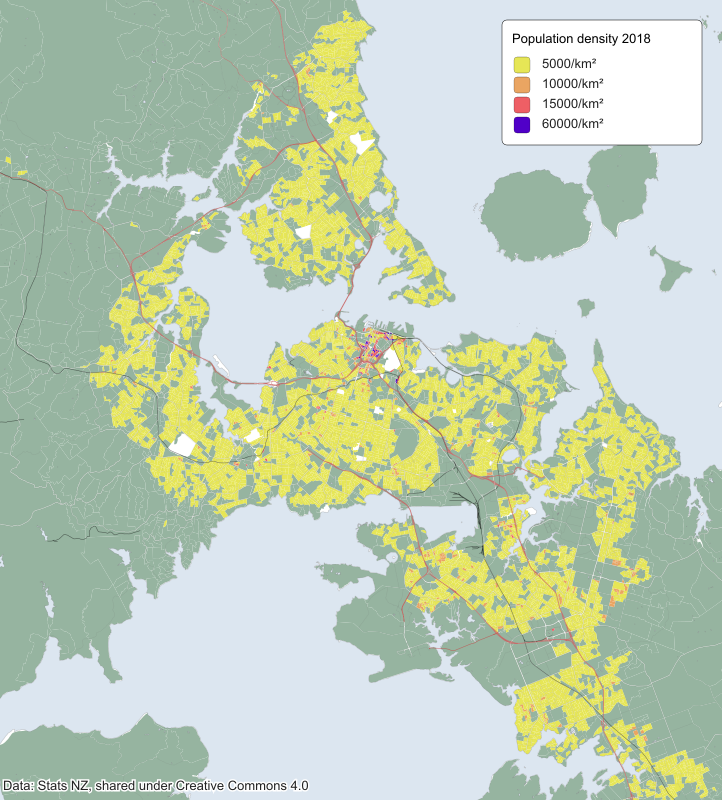
If you render the SA1 data set with a similar color scheme you can see the endless blob of yellow. A lot of the gaps are commercial and industrial areas, and town centres (!).
Brussels has 19 mayors. Which is to say, Brussels Capital Region has, but that region doesn’t actually encompass the entire city. Long story.
Yes of course you do find strip malls in Europe. But they’re not the only place where you’ll find shops. In Auckland even your local dairy sits in its own miniature ‘commercial’ zone enclave in a residential zone. Check out the Unitary Plan if you don’t believe me.
How much easier would it be to start a business if you were allowed to convert your living room to a shop front?
Doesn’t Auckland have town centres? Yes it does, but these have no population, only shops.
Even though European city centres depopulated to some degree during the 20th century, it went nowhere near as far as in the New World. Auckland city centre had a population of under 2000 in the early 1990’s.
This development was built in the tail end of the leaky homes crisis, and seems to have been quite badly afflicted. I’m not sure how this actually still maintains this population.
Read Traditional Euro-bloc: what it is, how it was built, why it can’t be built anymore to learn how that works.
Wet van behoud van ruimtevraag (Dutch) gives an insight in the various steps in the growth of the city of Amsterdam, and the effect of this history on urban form.
My hypothetical block of cottages has a density of 15,000/km², while still being distinctly suburban and small-scaled everything. Add in some parks, schools, etc to get your 10,000/km² suburb.
Again, leaky homes crisis. I swear I didn’t pick those 2 on purpose. How much more of this high-density housing would we have if this crisis wouldn’t have poisoned the well?
Post a Comment