
The Wrong Side of my Car
The blog that wants to go obsolete
The isthmus buses really are better
I often tell people that there is one little corner in Auckland with an existing functional public transport network: the western half of the isthmus. That’s it. Usually the response from public transport advocates lies somewhere between derision and bewilderment. I find this odd, because this is completely obvious if you just look at a bus map.
A line is not a network
It is baffling how often people argue that the North Shore has good public transport because it has a busway. It is analogous to arguing that on the isthmus, once the trains are frequent all day, it is OK to drop the frequency of all buses to 30 minutes, because hey you have two train lines. That proposition would be insane.
A minimal viable product
If we’re talking about how to get people on a bus, what we really mean is how to make it a sane option for people to take the bus instead of driving a car. So now we have to wonder, why is driving usually a sane option?
It is because:
- You can go anywhere you want
- at any time you want
- reasonably quickly
- and predictably.
How do we achieve (1) with buses? The most obvious requirement is enough bus lines. Most homes must have a bus line relatively closeby. Otherwise, right of the bat, you need so much time walking to a bus stop you might as well forget about it.
But that isn’t enough. One bus line only allows you to reach a small ribbon of area. There are a few things you can do about this, but the thing that actually works is to have other lines going in a kind of perpendicular way. In Auckland these are usually called cross-towns.
And ideally you’d be within walking distance of one of both, so you can immediately get going in 4 directions.
So, in short, your network must have:
- Enough lines
- Cross-towns
To achieve (2), (3) and (4), the most important thing is to ensure you never have to wait long for a bus. Think about reliability for instance. People often think about things like getting stuck in traffic. But what really ruins reliability is that if you’re a few minutes late for some reason, all of a sudden your trip gets 30 minutes later because you miss your bus.
As the adage goes, frequency is freedom.
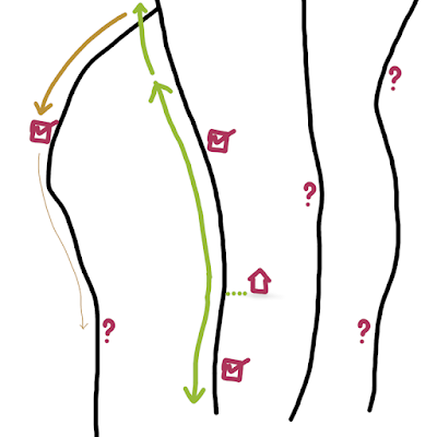
The isthmus
So map time. 15 minute (or better) headways only. What have we got on the isthmus:

I think this counts as a viable network. At least west of Manukau Road. Many lines. A non-zero number of cross-towns. But in the grand scheme of Auckland, it is only a small area that is covered in a useful way. *1
Did you count the lines? The 8 or so kilometres between Cornwall Park and the coast in Waterview is intersected by 6 lines. I think this amount is necessary, so most people have one of those lines within a reasonable walking distance.
The North shore
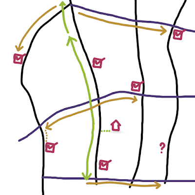
What could be
The North Shore is about 8 km wide, measuring from Beach Haven to the east coast bays. So let’s draw 6 north south lines on the map. Beach Road, Forrest Hill Road, Wairau Valley Road, Sunnybrae Road, Glenfield Road and Birkdale Road *2. Now, cross-towns. Add the Birkenhead cross-town, and extend that fourth line to Beach Haven to sort of act like a cross-town. And replicate the cross-town part of line 83. There is also this line to Westmere, so the Shore can have that Birkdale loop.
Oh, and Devonport. Everyone always forgets about Devonport *3.
Oh, wow. Overkill, anyone? Surely… But no, if you draw the isthmus network over this map it shows we’re not that far off.

Actually
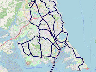
What have we actually got on the Shore?

So, viable? No. Some areas are not covered at all, and almost none have easy access to bus lines in more than one direction. There are no frequent cross-towns.
Auckland
Looking at the map of Auckland, most areas are more like the North Shore. I didn’t spot much of a grid anywhere outside the isthmus. If you’re on the isthmus and you’re wondering why the rest of Auckland needs cars, well, take a moment to appreciate just how far ahead you are when it comes to public transport provision.
So whenever you hear about people living car free, they always, unsurprisingly, happen to live in this little corner of the isthmus. Now the pigeon hole principle applies. It is a small area with relatively restrictive zoning. Access will be rationed by charging a premium for the privilege.
It should be possible in more parts of Auckland to live car free without simply becoming home bound. This will be quite difficult without a good public transport network. We have a long way to go.
You know what I didn’t draw on this map? Train lines. They’re still not frequent during the day.
If you do any attempt at drawing a hypothetical bus network, it is immediately obvious that Smales Farm should be the centre of the North Shore. There was actually a proposal for a town centre over there a long time ago, but a bit of good old lobbying—corruption is not a politically correct word here—the town centre materialised in Albany instead, and the site of the town centre is now a golf course.
Not really. But it would be their own stupid fault. Locals rejected a significant upgrade to Lake Road a few years back because it may make it accessible to those people who don’t drive cars, oh yuck!
The two lines over the bridge is not just a stylistic choice, you genuinely have to go all the way to Victoria Park to connect between these lines. It should actually be 3 lines, there is no connection to the 82 either, but since you can easily go from Takapuna to the busway on Smales Farm anyway it doesn’t matter a lot.
Post a Comment